[ Article ]
From Raw Data to Business Intelligence
Written by Kurt Janssen
30 May 2023
Share this post
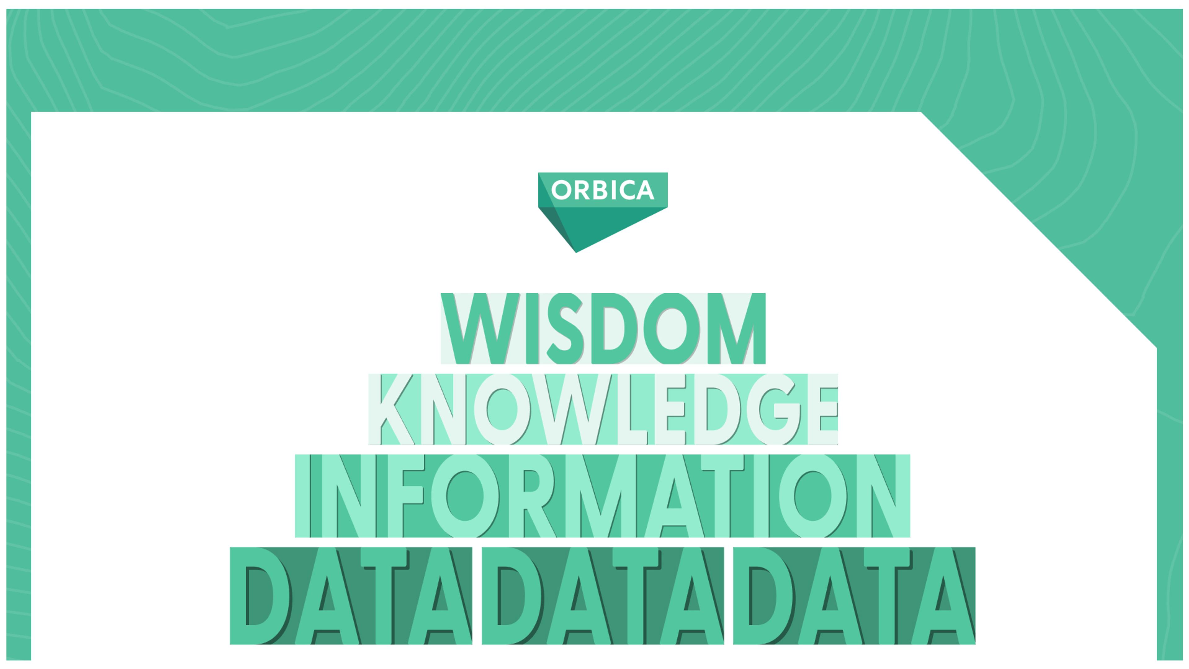
How Geospatial Analysis can help you Climb the DIKW Pyramid
Understand how to leverage geospatial analysis to transform your raw data into information, knowledge, and – ultimately – wisdom that drives your business growth
Introduction
Business landscapes are awash with data - torrents of it flowing through every corner of modern organisations. And although data-driven organisations scramble to harness this data, its full potential often remains untapped. Why? Because effectively climbing the DIKW pyramid requires broad access to geospatial analysis and insights. An ingredient many organisations still lack.
The DIKW pyramid is a powerful conceptual model for understanding data in its various forms. At the base, you have raw data, waiting to be turned into something meaningful. As you ascend, this data becomes information, then knowledge, and finally, wisdom that drives business growth.
However, many data-driven organisations grapple with constraints like technical limitations, data silos, and process bottlenecks that prevent a successful ascent up this pyramid. In this article, we will explore how you can equip your organisation with the right geospatial analysis tools, capabilities, and knowledge to navigate these challenges and ensure a successful climb.
Ready? Let’s dive in…
TLDR; The DIKW pyramid model illustrates the transformation of raw data into valuable wisdom. To successfully navigate this pyramid and drive business growth, organisations need to leverage geospatial analysis tools, capabilities, and knowledge.
Table of Contents
- Understanding Role of Geospatial Analysis in the DIKW Pyramid
- How Silos Impact Your Ascent up the DIKW Pyramid
- Unlocking Success with Broad Access to Geospatial Analysis
- Creating Positive Feedback Loops that Drive Business Growth
Understanding the Role of Geospatial Analysis in the DIKW Pyramid
The DIKW pyramid is an effective model for understanding the transformation of raw data into wisdom. It is structured as an information hierarchy with four distinct layers. At the base, we have raw data – simple unprocessed facts. As we move upwards, we convert these facts into information by adding context. The next layer, knowledge, is formed by interpreting this information and discerning patterns. At the pinnacle of the pyramid, knowledge is consolidated into wisdom, a profound understanding that informs decision-making.
However, a common roadblock organisations face on their ascent is a lack of context due to silos and tech constraints. When different departments are operating in data silos, they tend to view datasets in isolation. This leads to various departments conducting disjointed analyses and, essentially, moving up separate pyramids. And although they may produce valuable information and knowledge, they struggle to transform their insights into wisdom due to the lack of a holistic big picture view.
Enter geospatial analysis. Geospatial analysis plays a significant role as you climb the DIKW pyramid because it ties together all your disparate data sources. Although your datasets may seem disconnected, all data is anchored to a time and place. And by layering different datasets on top of one another based on this spatiotemporal component, you can access a whole new level of location-specific trends and insights.
By integrating geospatial analysis right from the foundational layer, organisations can gain a deeper understanding of the relationships between their datasets. This allows them to form holistic, forward-thinking solutions to complex problems and drive sustainable business growth.
How Silos Impact Your Ascent up the DIKW Pyramid
But one of the biggest roadblocks to integrating geospatial analysis across the organisation is the typically siloed nature of GIS departments. This is often propagated by old-school GIS technology with constraining licencing and poor usability for non-expert users. As such, geospatial analysis can quickly become a bottleneck. This is evident when vast amounts of data need to be analysed, but only few people within the organisation have the capabilities to do so.
Unsurprisingly, these GIS silos can significantly hinder the journey up the DIKW pyramid. They limit access to geospatial tools, knowledge, and capabilities and prevent cross-functional collaboration. This results in a lack of innovation and restricts the extraction of meaningful insights from data. By disrupting the ascent up the DIKW pyramid, these silos curb the potential of organisations to drive results.
Unlocking Success with Broad Access to Geospatial Analysis
Eliminating these GIS silos and broadening access to the right geospatial analysis tools, capabilities, and knowledge is crucial to facilitate the seamless transition from data to wisdom. And the best place to start is by looking at your GIS tech. Many old school enterprise GIS solutions further propagate silos due to their constraining licensing models and lack of user friendliness. This limits their use to select few individuals in an organisation, instead of enabling everyone to leverage geospatial analysis in their workflows.
To keep up with the ever-increasing demand for geospatial analysis and stay ahead of the curve, we need to break GIS out of its siloes and into the wider organisation. This requires accessible, easy-to-use tools that make geospatial analysis and data available for all to use and learn from.
This ease of use and democratisation aspect is a core premise of the Orbica geospatial platform. With scalable licensing and a strong focus on ease-of-use for non-GIS professionals, it opens up a world of possibilities in how you can use, analyse, and share your geospatial data assets.
And when you’re equipped with the right geospatial analysis tools, the climb up the DIKW pyramid becomes less daunting. The knowledge layer transforms into a platform for storytelling, turning complex data insights into compelling narratives that resonate with audiences. This, in turn, stimulates decision-making and behaviour change, propelling you towards the final layer: wisdom.
Creating Positive Feedback Loops that Drive Business Growth
Reaching wisdom in the DIKW pyramid is not a one-time ascent, but a continuous feedback loop of learning and understanding. Wisdom should never be static. Once decisions are made and changes begin to occur, it's crucial to monitor, track, and understand the outcomes. Any gaps found should be re-injected back into the system, allowing new methodologies, algorithms, and techniques to be introduced and the pyramid to be traversed again.
But reaching wisdom isn't merely the result of an analytical process; it is the art of applying the right knowledge in the right context at the right time. It involves understanding complex systems, recognising patterns, anticipating outcomes, and making sound decisions based on this holistic comprehension. And as we make decisions and effect change, we must constantly monitor outcomes, learn from them, and feed these learnings back into the system. This cyclic process enables us to continually re-climb the DIKW pyramid, each time with more sophistication and precision.
Democratising access to geospatial tools, capabilities, and knowledge fuels this process. By breaking down silos, we create an ecosystem where data is freely accessible and continually enriched. This not only empowers individuals to generate insights but also fosters a collaborative environment where knowledge is shared and wisdom is collectively built.
Wrapping Up
In our data-rich business world, effectively transitioning from raw data to business wisdom is a challenging but crucial task. This journey is best represented by the DIKW pyramid. Starting from the base, we transform raw data into context-driven information, then glean knowledge from discerned patterns, and ultimately reach wisdom - a level of profound understanding that fuels informed decision-making.
Unfortunately, many organisations falter in this journey due to siloed departments and tech constraints. Here, geospatial analysis is a key solution, tying together disparate data sources to unearth valuable location-based trends and insights.
However, the siloed nature of GIS departments often proves to be a barrier to integrating geospatial analysis. With the help of accessible, easy-to-use geospatial tools like the Orbica geospatial platform, we can democratise the process, enabling a more fluid ascent up the DIKW pyramid.
Talk to one of our team today to learn more about how the Orbica geospatial platform can help your organisation climb the DIKW pyramid and stay ahead of the curve.